Open full screen map
The Kp-index is a scale used to characterize the magnitude of geomagnetic disturbances. A geomagnetic storm starts at Kp5 after which the G-scale is also used.
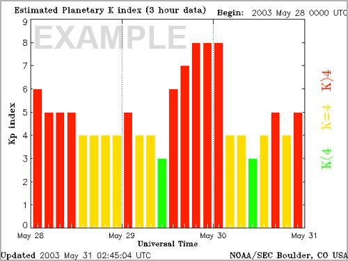
- Kp0 = Quiet
- Kp1 = Quiet
- Kp2 = Quiet
- Kp3 = Unsettled
- Kp4 = Active
- Kp5 = Minor storm (G1)
- Kp6 = Moderate storm (G2)
- Kp7 = Strong storm (G3)
- Kp8 = Severe storm (G4)
- Kp9 = Extreme storm (G5)
Magnetometers measure the strength of Earth’s magnetic field to determine the K-index, which is tied to a specific station. The Kp-index is calculated by combining the data from multiple magnetic observatories around the world to determine the global planetary index. See the current Kp-index on the Live Data page.
The map above shows you what the Kp-index needs to be to see the aurora overhead at a given location. Generally once the Kp-index reaches a certain threshold it will fill the northern half of the sky (in the northern hemisphere) all the way up to the zenith along the corresponding line on the map. If the current Kp-index is greater than the line shown on the map, the aurora will often fill the entire sky. If the Kp-index is slightly less than the line shows for a given location, the aurora may still appear low on the horizon. But a perfect viewing location and good eyes are usually required to see it. This is when a camera is helpful to pick up fainter displays. During the strongest of geomagnetic storms faint auroras have even been spotted in the southern US.
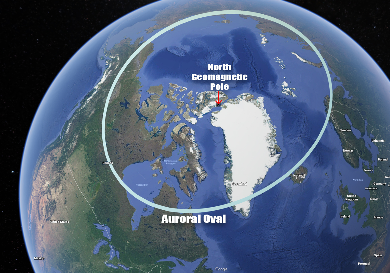
Auroral Oval
The light blue Kp0 line represents the location of the auroral oval. The auroral oval is a ring around the earth’s poles where the aurora likes to hang out. Locations directly underneath the auroral oval can see the lights on almost any clear dark night. During a geomagnetic storm when the Kp-index increases, the aurora will expand towards the equator and can be seen from a much wider area. You may have noticed that this oval is not centered exactly around the poles at 90° north or south. It is actually centered around the geomagnetic poles, which are different from the geographic poles. The geomagnetic north pole is currently (as of 2020) located at 80.7°N, 72.7°W, Ellesmere Island, Canada. This means that North America has a big advantage when it comes to seeing the northern lights. The lights can commonly be seen from much further south in North America compared to Europe and Asia, which are further from this pole. This explains why locations near the US-Canada border see the aurora a couple times a month on average while similar latitudes in Europe virtually never see the lights. The southern geomagnetic pole is much closer to Australia compared to Africa or South America. This is why Tasmania and New Zealand commonly see the southern lights while other continents do not. A simulated view of the current auroral oval can be seen on the live data page.
More About the Map
I used the information found on this NOAA page to determine where the Kp lines would be. This calculator was then used to convert the geomagnetic latitudes to geographic. I plotted 360 coordinate points in each hemisphere. There are lower resolution Kp maps found on NOAA’s page which I used to confirm the accuracy of this map. The KML file can be downloaded at this link, but there are some bugs with the Google My Maps viewer.